Clicking or tapping a colored rectangle on the map will zoom the map into that rectangle.
Click on the dice  to fly to a random site.
Click on a news article title to fly to a site associated with that article.
Double-click to zoom in and center the map on the spot where you have double-clicked.
Click the magnifying glass  then enter a location to zoom to that location on the map.
View the full map by clicking on the full screen icon 
All the sites shown on the map are from the sources listed below. Ancient Sites has collected this data and merged it to the map. Please support these excellent sites, supplying them with data which we can then display here.
 Megalithic Portal
 Wikipedia
 James Q Jacobs
 Pleiades
 Ancient Locations
 Vici
Vici Ad Hoc - Various public data sources
Our data merging process is far from perfect, so you will see sites duplicated on the map. We are working to improve this process
Legend
 | Art |
 | Fortification |
 | Industrial |
 | Monument |
 | Museum |
 | Natural |
 | Transportation |
 | Settlement |
 | Sacred |
 | Structure |
 | Unclassified |
 | Unknown |
Click on the drag-drop 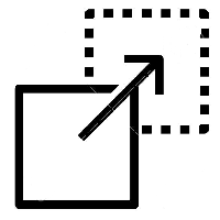 icon then select files from
any map layer files accessible from your device. File types are determined
by their file extension. Available file types are:
icon then select files from
any map layer files accessible from your device. File types are determined
by their file extension. Available file types are:
- shape files - require the zip extension
- Google kml
- Google kmz
- geoJSON - assumed if any extension other than the above
Ancient Sites is developed and supported by Entiro Systems Ltd. This site is both a work of interest by us and a demonstration of the type of work we do.
At Entiro we specialize in:
- Data acquisition
- Data modelling and deployment
- Web based mapping interfaces
- Python, Javascript, Leaflet, PostgresSQL
- A whole bunch of other good stuff
You can email us or visit our website.
Choose a story
You can drag and drop map overlay
files on to the dashed box below.
File types: .zip (shape files), geoJson, kml and kmz.

